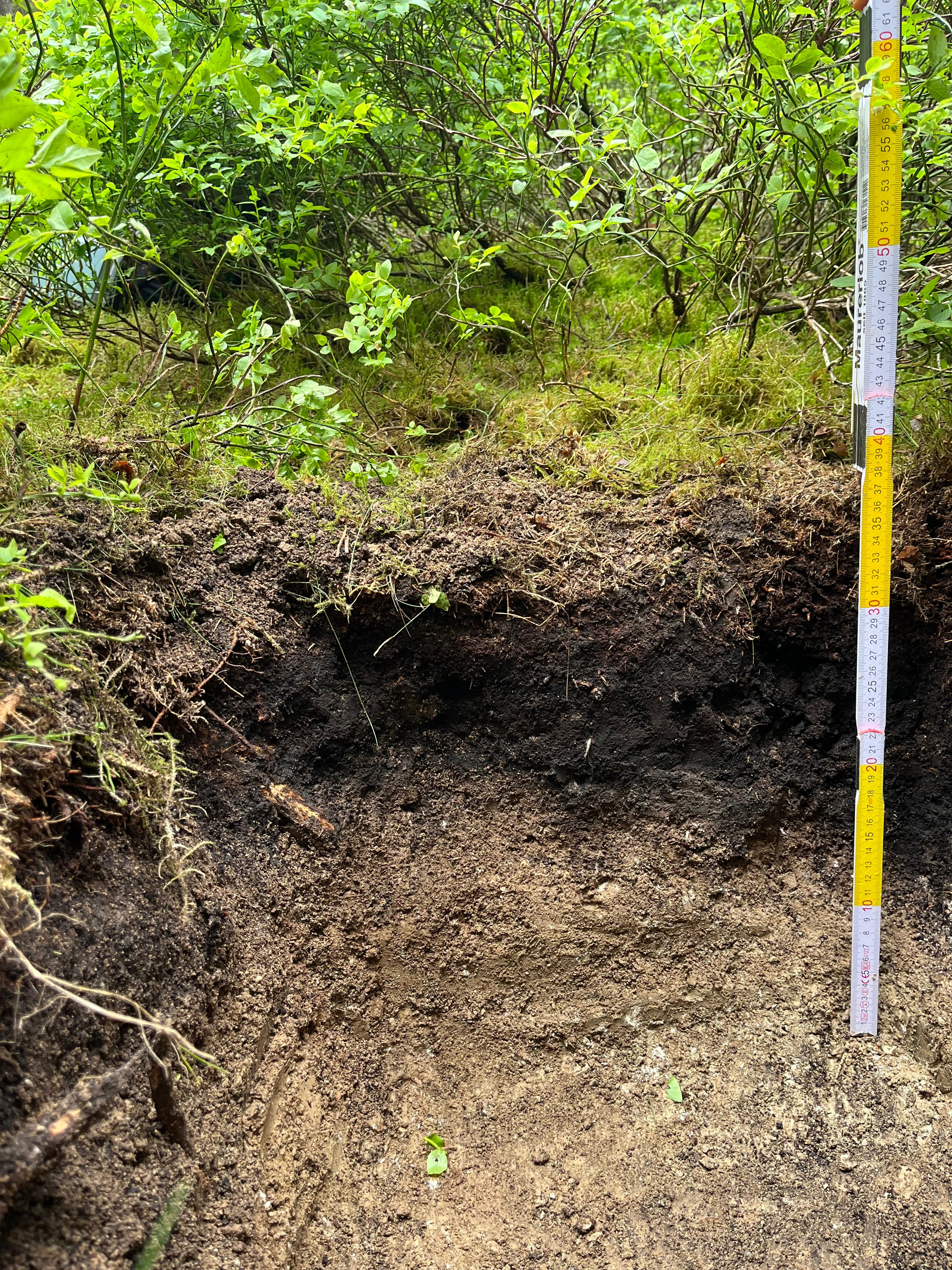
Profiles 2025KPG01P01
KA5 Reference ID: 1125

2025KPG01P01

Profile detailed view

Digital Object Identifier https://doi.org/10.4228/zalf-kyza-rk4
Author
Anika Engel
Date
17.05.2025
Location
11.8931, 50.0500
Status
Published
Profile is publicly visible

Pedon

Click on a horizon to open the detailed data.

Metadata

Status
Public
Profile name
2025KPG01P01
Nomenclature
KA5
Recording date
17.05.2025
Surveyor
Gruppe 1
Project
soils.uni-hannover
Description
—
Project remark
Bodenprofile, die im Rahmen von Kartierpraktika erhoben werden.

Funding reference

Funding name
Studienqualitätsmittel der Leibniz Universität Hannover über die Abteilung Bodenkunde
Award Number
—
Funding agency
—

AGROVOC thesaurus

Contributing people

Anika Engel

Corresponding Author
Role
author
Organization
Leibniz Universität Hannover
E-mail
anika.engel@stud.uni-hannover.de
ORCID
—
Street
—
Postal code
—
Location
—
Country
Deutschland

Lucie Bruns

Role
author
Organization
—
E-mail
lucie.bruns@stud.uni-hannover.de
ORCID
—
Street
—
Postal code
—
Location
—
Country
Deutschland

Charlotte Messerschmidt

Role
author
Organization
—
E-mail
charlotte.messerschmidt@stud.uni-hannover.de
ORCID
—
Street
—
Postal code
—
Location
—
Country
Deutschland

Nora Katharina Weigel

Role
author
Organization
—
E-mail
nora.katharina.weigel@stud.uni-hannover.de
ORCID
—
Street
—
Postal code
—
Location
—
Country
Deutschland

Patrick Liebmann

Role
Project lead
Organization
Leibniz Universität Hannover
E-mail
liebmann@ifbk.uni-hannover.de
Street
Welfengarten 1
Postal code
30167
Location
Hannover
Country
Deutschland

Suggested Citation

Engel, A.; Bruns, L.; Messerschmidt, C.; Weigel, N.; Liebmann, P. (2025). 2025KPG01P01. BonaRes Soil Profile Database. https://doi.org/10.4228/zalf-kyza-rk4

General Information

Title data remark
—
Type of digestion
GG (flache Grabung (Teilprofil < 1 m))
Recording intensity
—
Survey depth (cm)
—
Weather
WT4 (regnerisch mit nicht sehr starken Niederschlägen innerhalb der letzten 24 Stunden)
soil organisms
—
Soil appraisal: soil type/genesis
Zustandsstufe: 5; Bodenzahl: 47
Additional documents
—
Classification according to WRB
TC (Technosol)
Survey situation remark
—
Profile remark
Ticket_Number:6538

Anthropogenic changes

—

Soil description

Soil type (short)
RQ (Regosol)
Soil systematic unit: subtype
RQn (Normregosol)
Soil systematic unit: variety
—
Soil systematic unit: subvariety
—
Substrate systematic unit: class
no value
Substrate systematic unit: type
—
Substrate systematic unit: subtype
—
Humus form
MO (typischer Moder)

Relief and or erosion information

Inclination
N0.2
Exposure
SE (Südost)
Curvature
—
Relief shape type
T (Tiefenbereich)
Metric data on relief form type
—
Micro-relief
—
Location in relief
F (Hangfuß)
Soil erosion/deposition processes
—
Soil erosion/deposition features
—
Degree of erosion
—

Use and vegetation

Type of use/sealing
F (Forst allgemein)
Vegetation coverage level
NW (Nadelwald)
Vegetation area proportion
—

Hydromorphological information

GWS
GWS4 (tief)
Rootable soil depth
—
Water level below surface
—
Degree of waterlogging
—

horizon 1 — L

-18.0–-14.0 cm
menu_book Atlas
L keine Angabe keine Angabe

Identification

Horizon number
1
Symbol (prefix)
—
Horizon symbol
L
Symbol (suffix)
—
Upper limit (cm)
-18.0
Lower limit (cm)
-14.0

Morphology / Description

Form, sharpness and position
—
Soil colour (free text)
—
Humus content
keine Angabe
Carbon content
—
Carbonate content
—
Soil colour
  • 10YR5/3

Hydromorphism

Hydromorphic oxidative
—
Oxidative: form
—
Oxidative: degree of expression
—
Oxidative: area proportion
—
Oxidative: size
—
Hydromorphic reductive
—
Reductive: form
—
Reductive: degree of expression
—
Reductive: area proportion
—
Reductive: size
—
Soil moisture
—

Structure

Other pedogenic features
—
Other: appearance
—
Other: degree of expression
—
Other: area proportion
—
Other: size
—
Aggregate packing type
—
Crack width
—
Pores
—
Tubes/channels
—
Structure form and aggregate size
  • bro, gra1 (Bröckelgefüge, Makroskala, < 50 mm)

Rooting and consistency

Fine roots
—
Coarse roots
—
Bulk density/decomposition stage
—
Consistency
—

Substrate

Substrate type
no value
Substrate genesis
keine Angabe
Texture of fine soil
keine Angabe
Total coarse fragments
—
Coarse soil fractions/proportions
—
Parent rock
—
Periglacial layers
—
Coarse soil components
—
Substantial inhomogeneity
—
Structural inhomogeneity
—
Stratigraphy
—
Air capacity
—
Saturated hydraulic conductivity
—
Layer
—

horizon 2 — Of

-14.0–-11.0 cm
menu_book Atlas
Of keine Angabe keine Angabe

Identification

Horizon number
2
Symbol (prefix)
—
Horizon symbol
Of
Symbol (suffix)
—
Upper limit (cm)
-14.0
Lower limit (cm)
-11.0

Morphology / Description

Form, sharpness and position
—
Soil colour (free text)
—
Humus content
keine Angabe
Carbon content
—
Carbonate content
—

Hydromorphism

Hydromorphic oxidative
—
Oxidative: form
—
Oxidative: degree of expression
—
Oxidative: area proportion
—
Oxidative: size
—
Hydromorphic reductive
—
Reductive: form
—
Reductive: degree of expression
—
Reductive: area proportion
—
Reductive: size
—
Soil moisture
—

Structure

Other pedogenic features
—
Other: appearance
—
Other: degree of expression
—
Other: area proportion
—
Other: size
—
Aggregate packing type
—
Crack width
—
Pores
—
Tubes/channels
—

Rooting and consistency

Fine roots
—
Coarse roots
—
Bulk density/decomposition stage
—
Consistency
—

Substrate

Substrate type
no value
Substrate genesis
keine Angabe
Texture of fine soil
keine Angabe
Total coarse fragments
—
Coarse soil fractions/proportions
—
Parent rock
—
Periglacial layers
—
Coarse soil components
—
Substantial inhomogeneity
—
Structural inhomogeneity
—
Stratigraphy
—
Air capacity
—
Saturated hydraulic conductivity
—
Layer
—

horizon 3 — Oh

-11.0–0.0 cm
menu_book Atlas
Oh keine Angabe keine Angabe

Identification

Horizon number
3
Symbol (prefix)
—
Horizon symbol
Oh
Symbol (suffix)
—
Upper limit (cm)
-11.0
Lower limit (cm)
—

Morphology / Description

Form, sharpness and position
—
Soil colour (free text)
—
Humus content
keine Angabe
Carbon content
—
Carbonate content
—

Hydromorphism

Hydromorphic oxidative
—
Oxidative: form
—
Oxidative: degree of expression
—
Oxidative: area proportion
—
Oxidative: size
—
Hydromorphic reductive
—
Reductive: form
—
Reductive: degree of expression
—
Reductive: area proportion
—
Reductive: size
—
Soil moisture
—

Structure

Other pedogenic features
—
Other: appearance
—
Other: degree of expression
—
Other: area proportion
—
Other: size
—
Aggregate packing type
—
Crack width
—
Pores
—
Tubes/channels
—

Rooting and consistency

Fine roots
—
Coarse roots
—
Bulk density/decomposition stage
—
Consistency
—

Substrate

Substrate type
no value
Substrate genesis
keine Angabe
Texture of fine soil
keine Angabe
Total coarse fragments
—
Coarse soil fractions/proportions
—
Parent rock
—
Periglacial layers
—
Coarse soil components
—
Substantial inhomogeneity
—
Structural inhomogeneity
—
Stratigraphy
—
Air capacity
—
Saturated hydraulic conductivity
—
Layer
—

horizon 4 — Ah

0.0–5.0 cm
menu_book Atlas
Ah h2 (schwach humos) c0 (carbonatfrei) feu3 (feucht) Uls (sandig-lehmiger Schluff)

Identification

Horizon number
4
Symbol (prefix)
—
Horizon symbol
Ah
Symbol (suffix)
—
Upper limit (cm)
—
Lower limit (cm)
5.0

Morphology / Description

Form, sharpness and position
w,di,h (wellig, Übergang diffus, Grenze horizontal)
Soil colour (free text)
—
Humus content
h2 (schwach humos)
Carbon content
—
Carbonate content
c0 (carbonatfrei)
Soil colour
  • 10YR4/3

Hydromorphism

Hydromorphic oxidative
—
Oxidative: form
—
Oxidative: degree of expression
—
Oxidative: area proportion
—
Oxidative: size
—
Hydromorphic reductive
—
Reductive: form
—
Reductive: degree of expression
—
Reductive: area proportion
—
Reductive: size
—
Soil moisture
feu3 (feucht)

Structure

Other pedogenic features
—
Other: appearance
—
Other: degree of expression
—
Other: area proportion
—
Other: size
—
Aggregate packing type
—
Crack width
—
Pores
—
Tubes/channels
—
Structure form and aggregate size
  • sub (Subpolyedergefüge)

Rooting and consistency

Fine roots
Wf2 (schwach)
Coarse roots
Wg0 (keine Wurzeln)
Bulk density/decomposition stage
Ld2 (Ld gering)
Consistency
—

Substrate

Substrate type
k.A.
Substrate genesis
keine Angabe
Texture of fine soil
Uls (sandig-lehmiger Schluff)
Total coarse fragments
20
Coarse soil fractions/proportions
—
Parent rock
*Gn (Gneis)
Periglacial layers
—
Coarse soil components
—
Substantial inhomogeneity
—
Structural inhomogeneity
—
Stratigraphy
—
Air capacity
—
Saturated hydraulic conductivity
—
Layer
—

horizon 5 — Cv

5.0–19.0 cm
menu_book Atlas
Cv keine Angabe c0 (carbonatfrei) feu3 (feucht) Uls (sandig-lehmiger Schluff)

Identification

Horizon number
5
Symbol (prefix)
il
Horizon symbol
Cv
Symbol (suffix)
—
Upper limit (cm)
5.0
Lower limit (cm)
19.0

Morphology / Description

Form, sharpness and position
—
Soil colour (free text)
—
Humus content
keine Angabe
Carbon content
—
Carbonate content
c0 (carbonatfrei)
Soil colour
  • 10YR5/3

Hydromorphism

Hydromorphic oxidative
ed (dunkelrostfarben)
Oxidative: form
ad (Adern, adrig)
Oxidative: degree of expression
—
Oxidative: area proportion
—
Oxidative: size
—
Hydromorphic reductive
—
Reductive: form
—
Reductive: degree of expression
—
Reductive: area proportion
—
Reductive: size
—
Soil moisture
feu3 (feucht)

Structure

Other pedogenic features
—
Other: appearance
—
Other: degree of expression
—
Other: area proportion
—
Other: size
—
Aggregate packing type
—
Crack width
—
Pores
—
Tubes/channels
—
Structure form and aggregate size
  • sub (Subpolyedergefüge)

Rooting and consistency

Fine roots
Wf0 (keine Wurzeln)
Coarse roots
Wg0 (keine Wurzeln)
Bulk density/decomposition stage
Ld2 (Ld gering)
Consistency
—

Substrate

Substrate type
k.A.
Substrate genesis
keine Angabe
Texture of fine soil
Uls (sandig-lehmiger Schluff)
Total coarse fragments
60
Coarse soil fractions/proportions
—
Parent rock
*Gn (Gneis)
Periglacial layers
—
Coarse soil components
—
Substantial inhomogeneity
—
Structural inhomogeneity
—
Stratigraphy
—
Air capacity
—
Saturated hydraulic conductivity
—
Layer
—

No samples available

Localization

GeoJSON coordinates
11.8931, 50.0500
Elevation above sea level
680.00
Topographic map sheet no.
—
Country
Deutschland
Federal State
Bayern
Place name
Fichtelgebirge/Vordorfer Forst
Remark
Profil neben Rinnen aus mittelalterlichen Zinnseifen-Tagebau. Aufgenommenes Bodenprofil entwickelt aus Gneisschutt des Tagebaus.

Attachments